St. George Island
Restoration
| Introduction |
Research Methods
Vegetation census: Six permanent vegetation grids were established at the eastern tip of St. George Island in 1998: 2 grids each in the foredune, interdune and backdune areas. Each grid is 60 x 60 m and contains a 7 x 7 array of plots, with each plot separated by 10 m, for a total of 294 individual plots covering almost 2.5 hectares. The site is in St. George Island State Park where research permits have been re-issued to T. Miller by the Florida Department of Environmental Protection to work on a variety of projects since 1992.
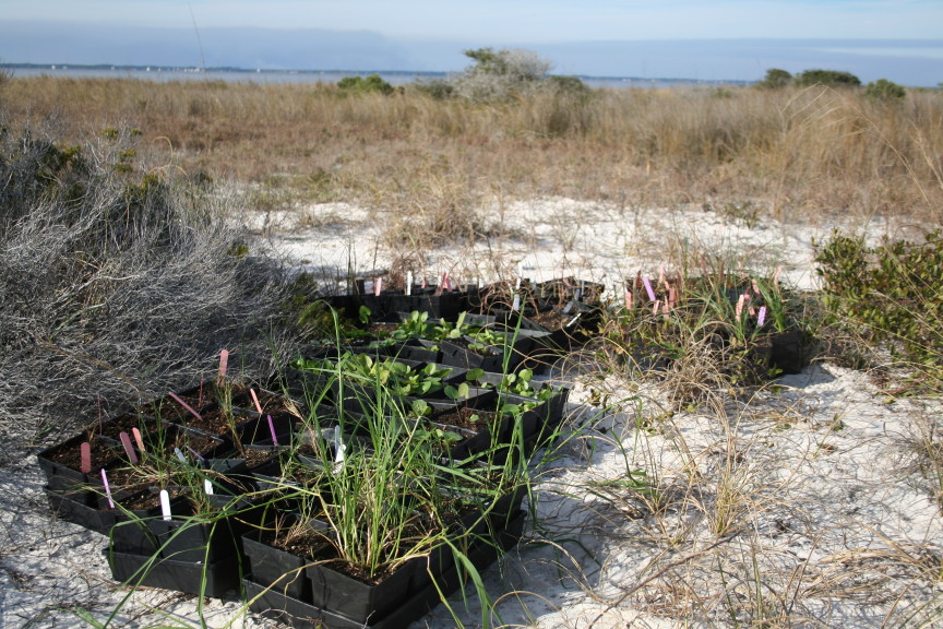
Since 1999, 10-15 graduate students and faculty volunteers from Florida State University have helped to census the 294 plots. Census teams consist of several data collectors and at least one botanist to insure accuracy and consistency. A 1-m² quadrat is placed over each plot and all vegetation is counted by # individuals, # clumps, and/or % cover by species. Each group uses standardized plant keys that are updated each year. Any unknown plants are sampled off the plots in replicate, given an ID number and identified later. Other aspects of each plot are also noted, such as dead plants or evidence of flooding or sand movement. I will also be responsible for incorporating this data into the long-term data base that is publicly available.Transplanting: We have identified six species with high restoration potential, based on their abundance in specific habitats and their responsiveness to storm events. These include Uniola paniculata , Fimbristylis spp., Sporobolus virginicus, Centella asiatica, Muhlenbergia capillaris and Paspalum spp. In November of 2007, 100 individuals of each species were collected from dense plots on St. George Island and transplanted to the Florida State University Department of Biological Sciences greenhouse. The plants were grown in individual pots in a soil:fertilizer mix. When the plants reached a maximum height, they were further seperated until 400 individuals of each species were potted. The plants were kept in the greenhouse for 3 months. Plants were then transplanted to disturbed areas in St. George Island State Park, with three replicates in each of the three dune habitats. Each quadrat is 6m x 5m, evenly divided into thirty 1m x 1m plots. Within each plot, one of each of the six transplant species were planted, for a total of 6 transplant per plot. 6 species x 30 plants/plot x 3 habitats x 3 replicates = 1620 transplants.
The plants are monitored bi-monthly for survival and growth.
Quantifying dune structure and hydrology: Samples have been collected from many of the major morphological features within the study area. Sediment characteristics will be determined from sites along 3 transects running from the beach inland through the foredune, interdune, and backdune plots to determine deposition signatures. Statistical analyses of the data will be carried out using analytical software developed by J. Donoghue (Department of Geology, Florida State University) for this purpose (Balsillie et al., 2002). Water table and the subsurface structure of the dunes and beach ridges will be mapped using ground-penetrating radar (GPR) surveys at different times of the year. We work with Dr. Donoghue using a MALA CU-II GPR system with 100 MHz and 250 MHz antennas along the same three transects used for textural analyses of the study area.
Several environmental variables associated with each plot are collected each year. Elevation of each plot relative to mean sea level is determined using a TopCon Total Station. Climate records will been obtained from Apalachicola, FL, providing data on weather and precipitation (National Estuarine Research Reserve System) and storm surge (NOAA). Gravimetric percent soil moisture is determined by collecting a 2cm diameter x 15 cm column of sand from one corner of each plot and placing the soil into an airtight bag. The samples are weighed, dried at 60°C, and re-weighed to determine percent soil moisture. Percent ash is determined using the same samples and re-weighing the samples after being heated in a combustion furnace. Detrended Correspondence Analyses (DCA) has been the exploratory tool used to identify suits of species that co-occur across the dunes, and to correlate these patterns with environmental variables.
Remote Sensing: LIDAR, satellite imagery, and aerial photos will soon be used to identify areas of similar vegetation and geomorphology as the St. George sites. A hand-held spectrometer is available through A. Stallins (Department of Geography, Florida State University) and will allow us to construct optical indices of plot-level community patterns based on vegetation and soil reflectance (e.g., Coops et al. 2004, Zaady et al. 2007). These indices can be used with LIDAR and other remote imagery to identify other similar areas along the Gulf Coast, where we may be able to also predict vegetation and geomorphological changes as a function of climate (see Lefsky et al. 2002).